
OVERVIEW
Isaias (ees-ah-EE-ahs) strengthened into a hurricane last night and continues to strengthen today. The forecast track has remained largely the same, with a landfall likely along the coastline of the AL/FL border. Confidence is increasing regarding impacts to North Georgia this weekend. Impacts include high winds, localized flash flooding, and brief, spin-up tornadoes. There remains some uncertainty about exacting timing, but impacts are likely to be felt late Friday through Sunday morning, peaking on Saturday. Please note that even though the Atlanta area is not included in the cone (Fig 1), we are still going to feel significant impacts from this storm.
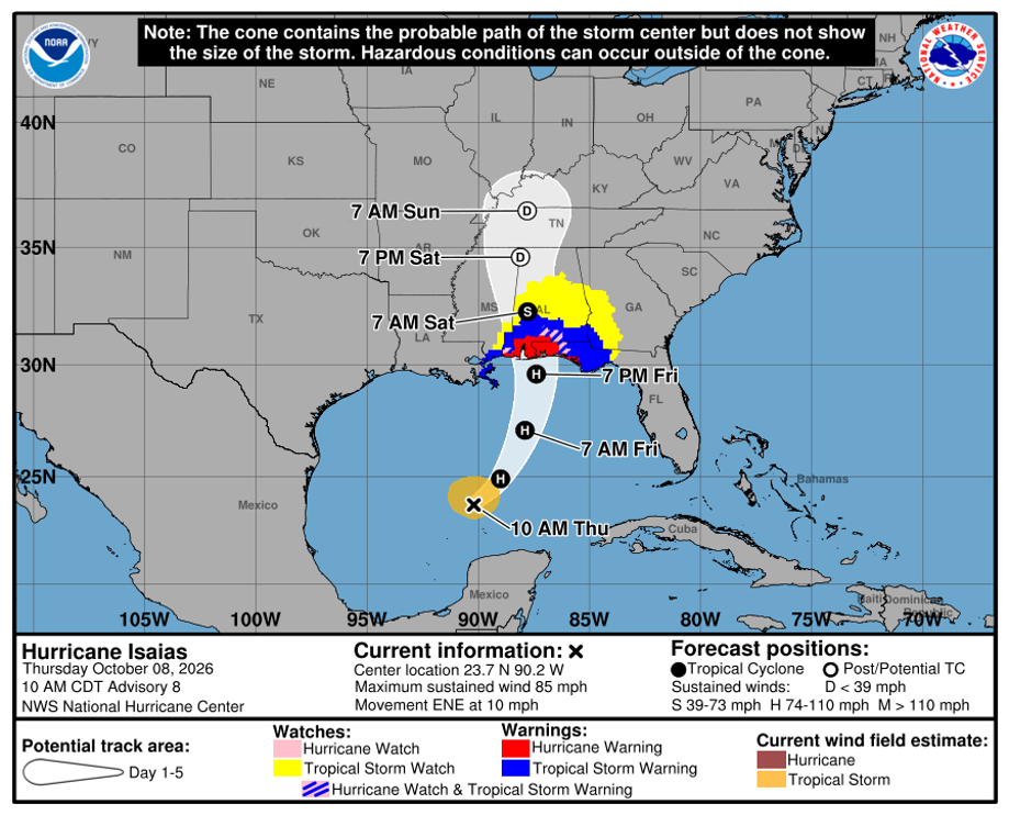
Figure 1: NHC/NWS Hurricane Isaias Forecast Cone
IMPACTS
Beginning late Friday through Sunday morning, Metro Atlanta will be impacted by damaging wind gusts, heavy rain/localized flash flooding, and spin-up tornadoes. The timeframe for most intense impacts seems to be 3am Saturday through 3am Sunday. Details regarding each hazard are outlined below.
Winds
A High Wind Watch has been issued for much of North Georgia, including campus, effective Saturday at 8am through Sunday at 8am. We are expecting a prolonged period on Saturday with winds gusting anywhere from 35-50mph. This may lead to downed trees and power lines. Scattered power outages are possible throughout North Georgia. Generally, campus is quite resilient to weather-related power outages due to our underground utilities.
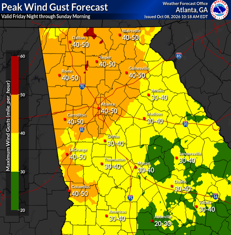
Figure 2: Peak Wind Gust Forecast Friday-Sunday
Heavy Rain/Flash Flooding
A Flood Watch has been issued for much of North Georgia, including campus, effective Saturday at 2am through Sunday at 8am. Light to moderate rain should begin Friday afternoon with intensity increasing throughout the overnight hours and through the day Saturday. Rain will not necessarily be constant, as feeder bands will rotate around the low in western Alabama. However, training of these bands of heavy rain and wind can lead to localized flash flooding, especially in flood-prone areas. Areal accumulations are expected to be between 1”-3” with some areas receiving upwards of 5”.
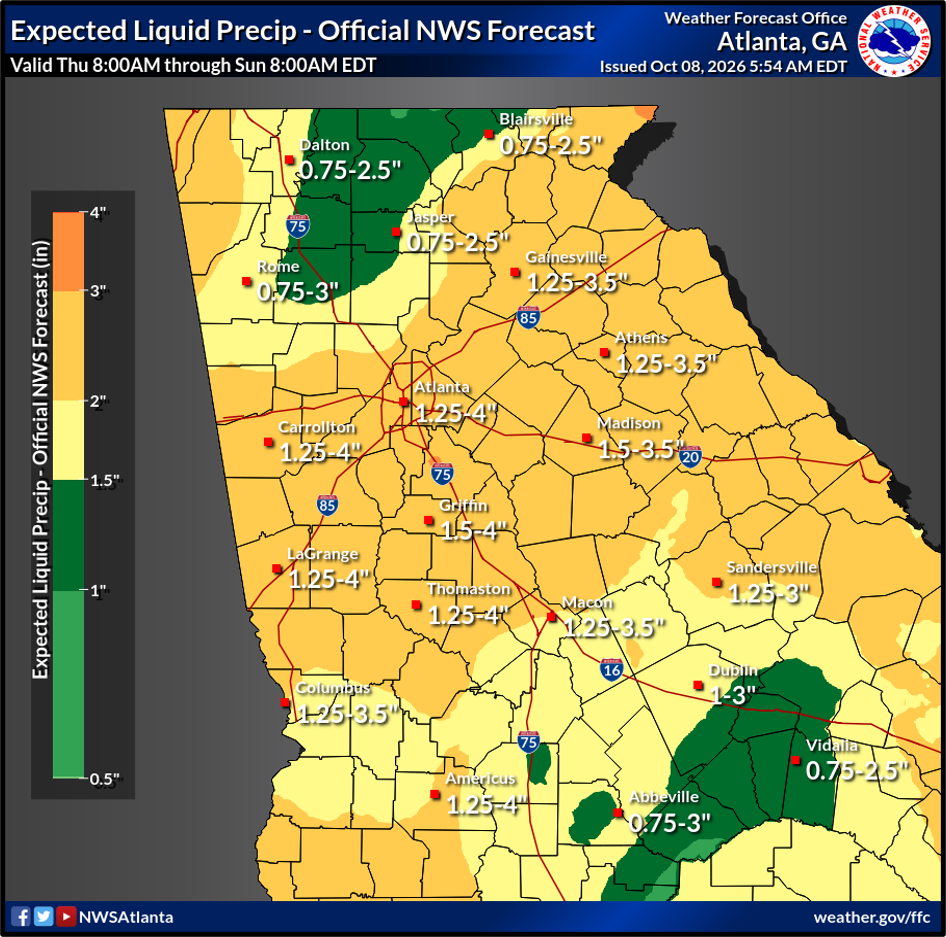
Figure 3: Forecast Rainfall Accumulation Ranges
Tornado
The tornado threat has increased since the last update. While less likely than the other hazards, forecast conditions appear to better support rotation within the outer bands, even this far from the center of the low. Tornadoes from tropical systems tend to be weak and short-lived. This does not mean that they cannot cause damage- just not damage like an EF-3+. A tricky aspect to forecasting/warning tropical-associated tornadoes is that they form very quickly and dissipate quickly. It is absolutely possible that by the time a storm is warned for a tornado, it has already dissipated and/or already caused damage. Keep this in mind if we do receive a warning. You will need to take shelter immediately.
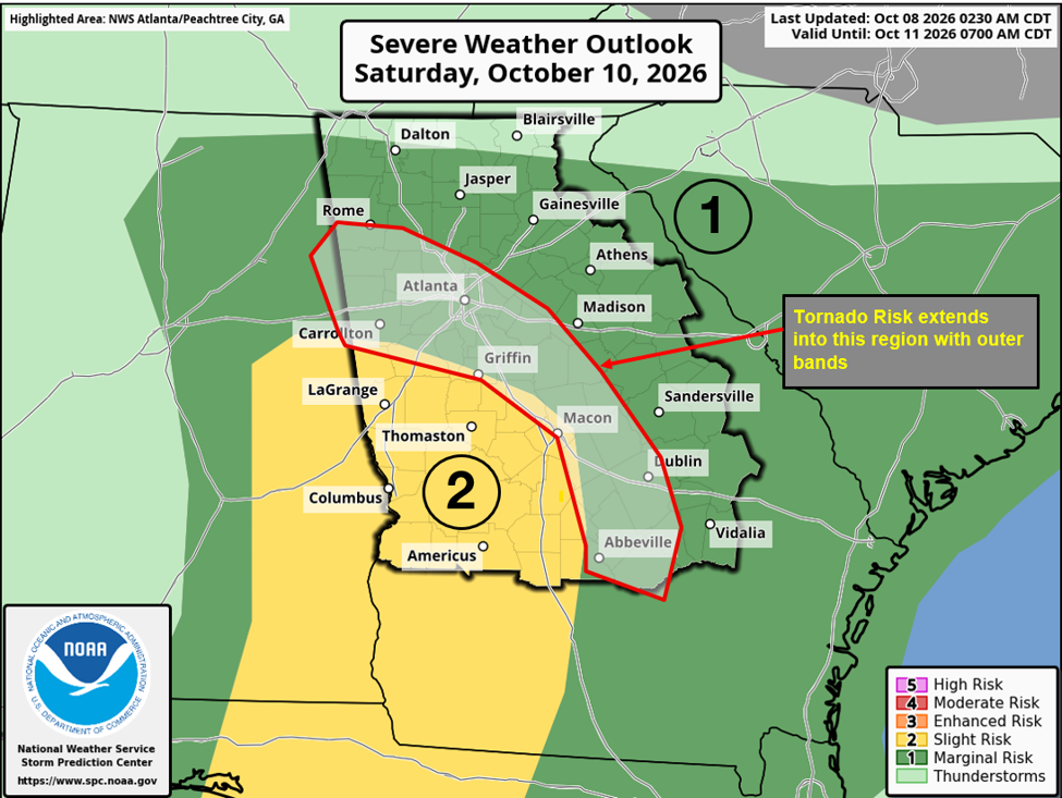
Figure 4: Severe Weather Outlook for Saturday
OEM will continue to monitor the latest model guidance and NHC/NWS forecasts to keep the campus community updated. Another Situational Awareness email will be disseminated tomorrow morning.
PRIMARY HAZARDS
- Damaging wind gusts
- Flash flooding in flood-prone areas
- Brief, spin- up tornadoes
NEXT STEPS
- The Georgia Tech Office of Emergency Management will continue to monitor the situation and provide another email update tomorrow morning.
- Follow the GT Office of Emergency Management on twitter @gtpdalerts.
- For the latest forecast information, please visit the National Weather Service.