
SITUATIONAL AWARENESS
OVERVIEW
Tropical Storm Isaias has formed in the southern Gulf and is expected to strengthen into a hurricane before making landfall late Friday/early Saturday. While Atlanta is not within the cone (Fig. 1), the rain shield will extend far from the center of circulation and impact Georgia Tech and Atlanta this weekend (Fig. 2).
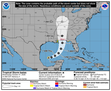
Figure 1: NHC/NWS Tropical Storm Isaias Forecast Cone
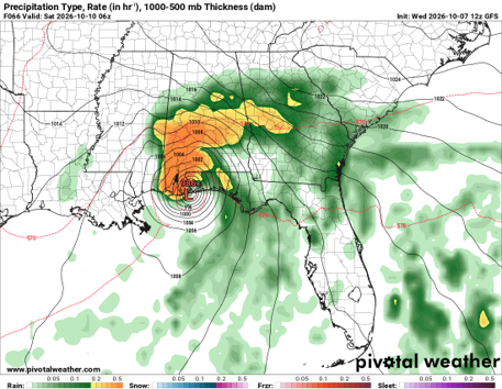
Figure 2: Swath of rain possible with Tropical Storm Isaias
Impacts
OEM is watching for two main impacts from Tropical Storm Isaias:
- Excessive Rainfall
- Strong, damaging winds
A slight risk for excessive rainfall exists (Fig. 3) which could lead to flooded roads and snarl traffic across the city on Saturday. Additionally, a risk for strong, damaging winds in excess of 40 mph could cause downed trees.
Continue to monitor the forecast through the weekend as timing of impacts to Atlanta will be determined as Isaias moves through the Gulf over the next day. OEM will provide Situational Awareness updates through the weekend.
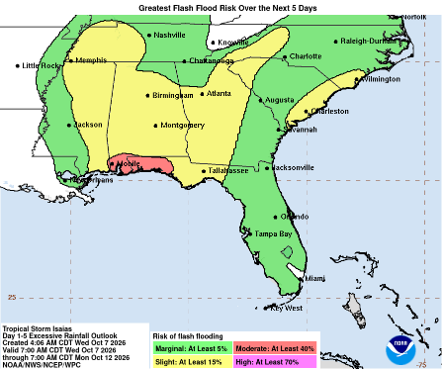
Figure 3: Excessive Rainfall Outlook
PRIMARY HAZARDS
- Flash flooding in flood-prone areas
- Damaging wind gusts
- Brief, spin- up tornadoes
NEXT STEPS
- The Georgia Tech Police Department Office of Emergency Management will continue to monitor the situation and provide updates as necessary.
- Follow the GT Office of Emergency Management on twitter @gtpdalerts.
- For the latest forecast information, please visit the National Weather Service.