LATEST INFORMATION
- A Winter Storm Warning is in effect for much of north and middle Georgia today.
- Additionally, an Extreme Cold Warning is in effect today for much of the state.
- Georgia Tech is in Modified Operations today and will assess conditions later today to make decisions about Sunday.
- Although snow progression into the area has been a bit slower than forecasted, snow is starting to develop across north Georgia.
- A band of snow arranged north to south is moving SSE into north Fulton and Gwinnett Counties at the writing of this report.
- Recent high-resolution models still show snow accumulations for metro Atlanta, but they should remain within the forecasted totals (.5” – 2”).
- Surface temperatures have been dropping steadily overnight and are below freezing across the region.
- Interstate road temperatures are generally hovering a few degrees above freezing.
- No road issues have been reported at this time.
FORECAST
Snow
The NWS still expects widespread snow accumulation today for much of the state, with higher accumulations towards the South Carolina state line. For Atlanta, .5” – 2” is the official forecast. Higher amounts are possible depending upon where snow bands develop and train over areas. Low surface temperatures will support immediate accumulations of even light snow. As such, travel issues are expected in any areas that receive even minor amounts of snow. While most primary roads have been treated, not all secondary roads or neighborhood roads have treatment and will likely degrade first. Campus roads have all been treated.
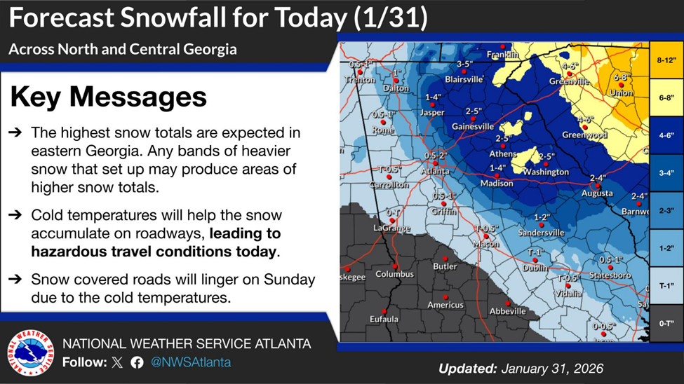
Figure 1: Forecast Snowfall (NWS Peachtree City)
Temperatures
Temperatures today should continue to fall into the mid 20s. Overnight, temperatures will fall to the mid teens, with a forecast low of 16°F. Temperatures on Sunday will rise slightly by the afternoon period but may not get above freezing. Monday morning’s low is expected around 25°F, but temperatures should rebound nicely by midday with a high in the low to mid 40s. Windchill values will be much lower, though, as strong northerly winds are expected to develop today across the region. Expect wind chill values to drop quickly today, dropping below 10°F by late morning and perhaps below 0°F by daybreak tomorrow.
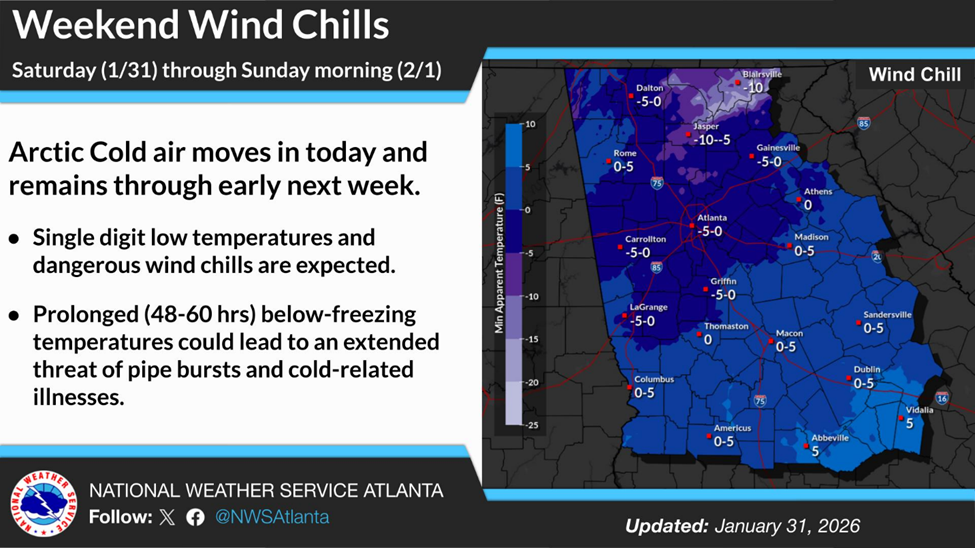
Figure 2: Forecast Wind Chills (NWS Peachtree City)
Wind
As mentioned in the temperature forecast, high winds today will make outdoor activity dangerous. Sustained winds will increase throughout the day, exceeding 20 mph, with gusts between 30 mph and 40 mph.
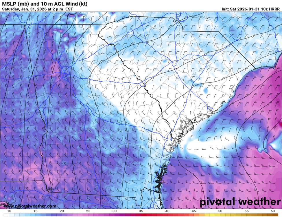
Figure 3: Surface Winds at 2PM (10z HRRR)
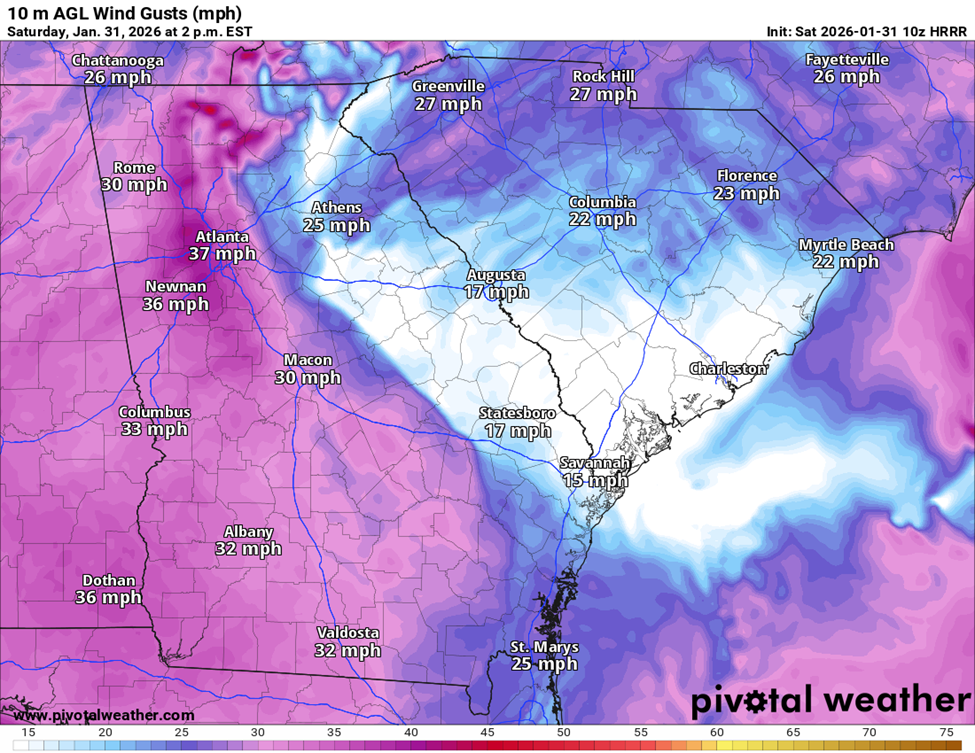
Figure 4: Wind Gusts at 2PM (10z HRRR)
PRIMARY HAZARDS
- Treacherous driving conditions for any areas that receive snow, especially on secondary and untreated roadways.
- Dangerously low wind chill values throughout the day Saturday and much of the day Sunday.
- Water leaks and main breaks from freezing pipes. (Mostly expected when temperatures rebound >32°F)
NEXT STEPS
- The Georgia Tech Police Department Office of Emergency Management will continue to monitor the situation and provide updates as necessary.
- Follow the GT Office of Emergency Management on twitter @gtpdalerts.
- For the latest forecast information, please visit the National Weather Service