OVERVIEW
A very cold air mass will enter the region as early as Friday evening and settle in for the weekend, with dangerously low temperatures through Monday. In addition, snow is possible across the region, although there remains some uncertainty on where the snow will set up. There are several challenges with the snow forecast as the air temperature will support larger liquid to snow ratios and allow for immediate roadway accumulations. At these temperatures, untreated surfaces will degrade quickly with only minor accumulations. The NWS has issued a Winter Storm Watch for much of east Georgia, and does not currently include metro Atlanta.
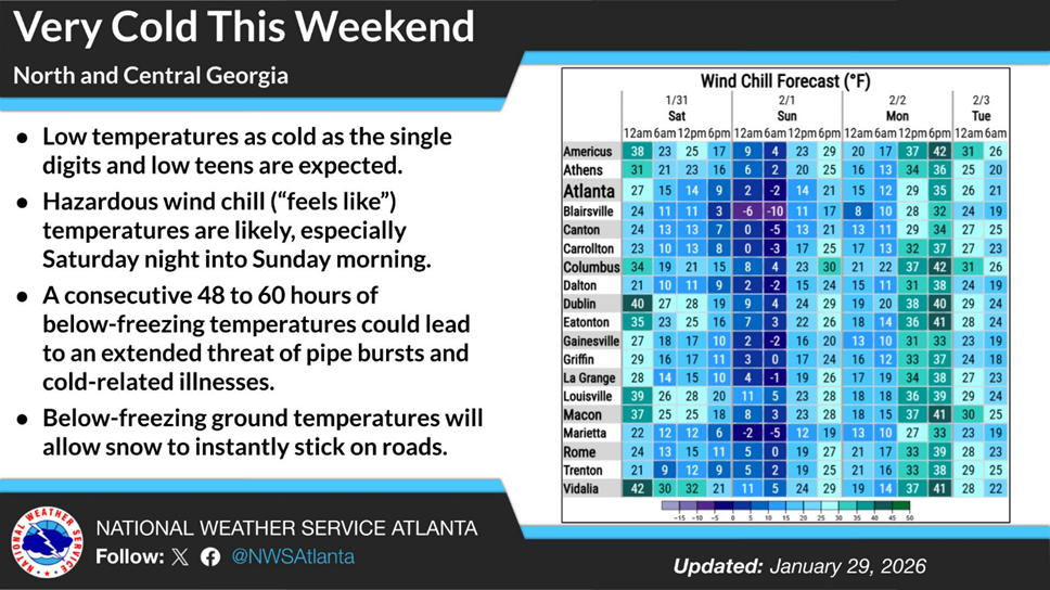
Figure 1: Wind Chill Forecast this Weekend (NWS Peachtree City)
TEMPERATURES
The arctic airmass will push into the region by late Friday and quickly drop the region below freezing for the next 60 hours. Lows on both Saturday and Sunday may dip into the low teens and will be accompanied by gusty winds that may push over 40 mph at times. Wind chill values will be dangerously low, with values approaching -10°F in some models. One challenge that the models have with the temperature forecast is the heavy snowpack across the Ohio and Tennessee River Valleys that may accelerate the cold air arrival and may lead to temperatures verifying lower than forecasted. Either way, it will be cold.
Cold-related illness is certainly a threat for persons outdoors throughout this period. Additionally, we expect additional pipe bursts over this period, especially as we exit the sub-freezing temperatures around midday on Monday. We expect the NWS to issue cold weather products for the entire region for this event.
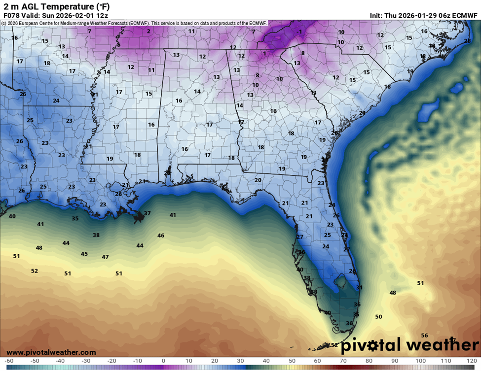
Figure 2: Surface Temperatures at 7AM EST (ECMWF 06Z)
WILL IT SNOW?
Where the snow will set up remains the biggest challenge with the forecast. Officially, NWS Peachtree City is forecasting .5” of snow for Atlanta. However, they still have low confidence on snowfall totals, especially for the more western areas of the state. There is still model divergence on snowfall for Atlanta, with some showing trace to no snowfall, others show more significant snowfall for the metro region. As mentioned earlier, liquid to snow ratios will be higher with this event (from 10:1 to 20:1), which compounds any forecast errors. Also keep in mind that at even seemingly insignificant accumulations, untreated roadways in this scenarios are prone to flash freezing, similar to what happened with Snowmageddon in 2014. Unlike that situation, we do have many roadways with a good amount of treatment from this past weekend and expect additional treatment ahead of Saturday. Still, expect even minor accumulations to cause some issues beginning as early as Saturday morning. Untreated surfaces with accumulations will certainly degrade quickly.
SNOW TIMING
There seems to be some agreement on timing, at least among the models that predict snow for Atlanta. Generally, snow may start as early as 4 AM Saturday morning and end as late as 2 PM.
NEXT STEPS
- The Georgia Tech Police Department Office of Emergency Management will continue to monitor the situation and provide updates as necessary.
- Follow the GT Office of Emergency Management on twitter @gtpdalerts.
- For the latest forecast information, please visit the National Weather Service.