WHAT’S CHANGED
The Ice Storm Warning continues this morning for all of north Georgia. Areas that were previously in a winter storm watch have been upgraded to a winter weather advisory. Confidence continues in that ice accumulations will impact power and make travel hazardous across north Georgia Sunday through Monday.
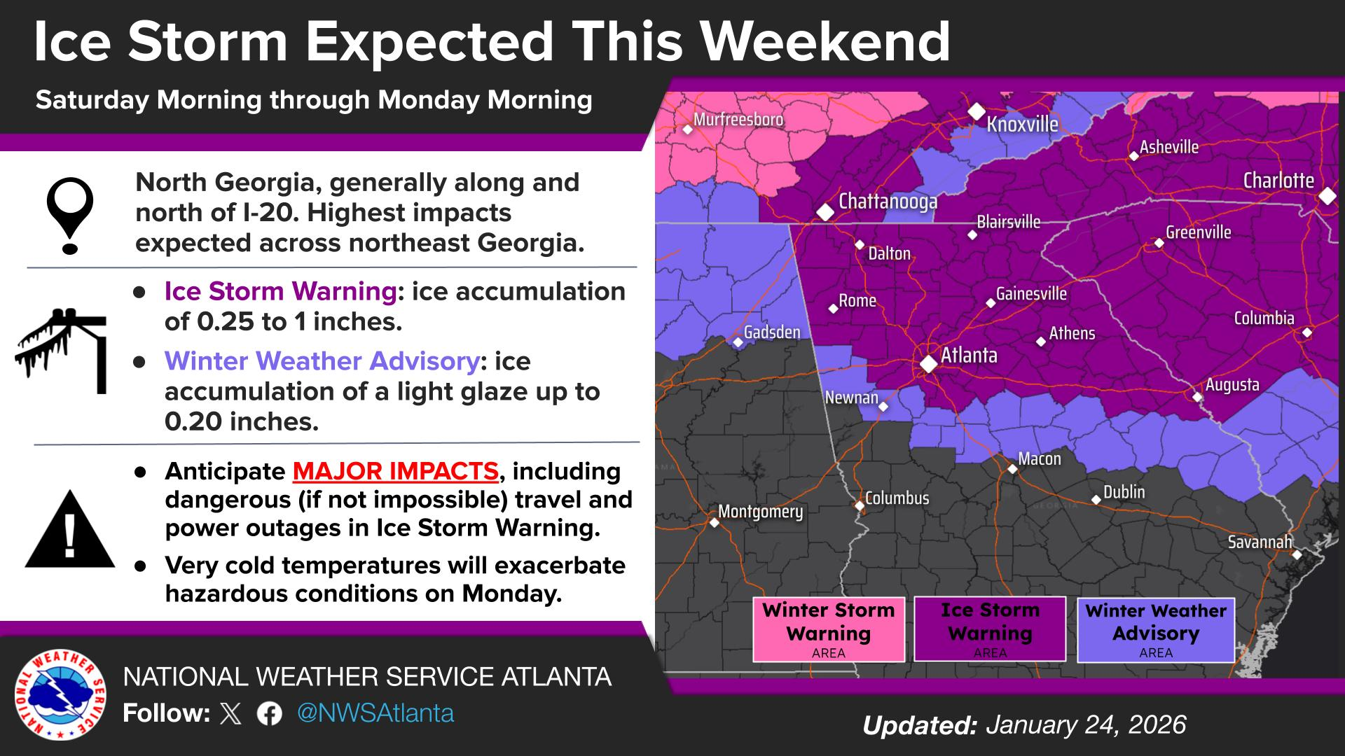
Figure 1: Winter Storm Watch & Ice Storm Warning Areas
TIMING
Generally, we should start to see freezing precipitation impact the region by late afternoon on Saturday. We are already watching some precipitation make its way across north Georgia, but with dry air aloft, most of it is not making it to the surface yet. As the atmosphere continues to saturate throughout the day, we will see precipitation start to make it to the surface in the form of frozen rain (ice) likely around the 7 pm time frame once temperatures dip as the wedge builds in from the northeast.
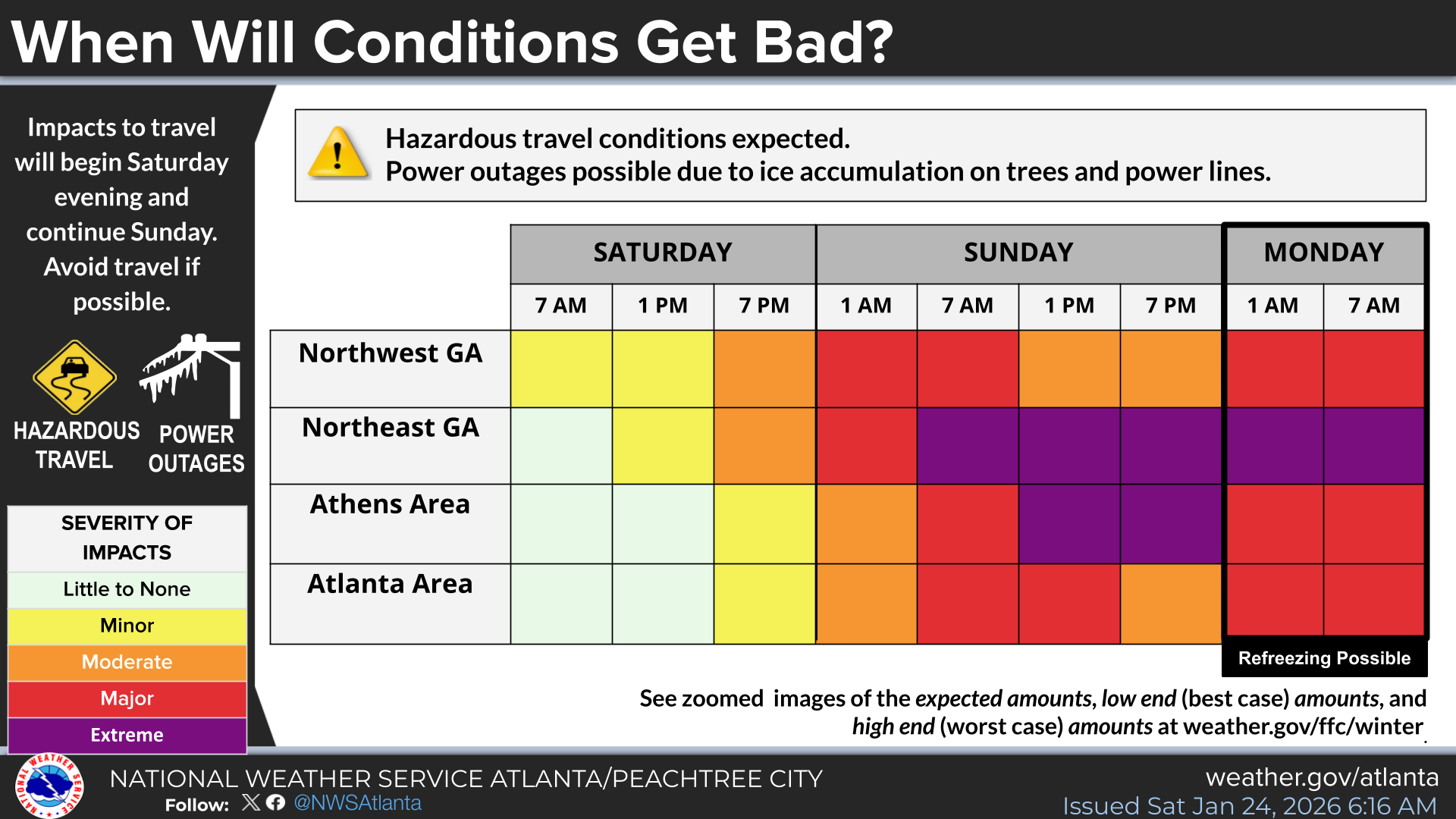
Figure 2: Impact Timing
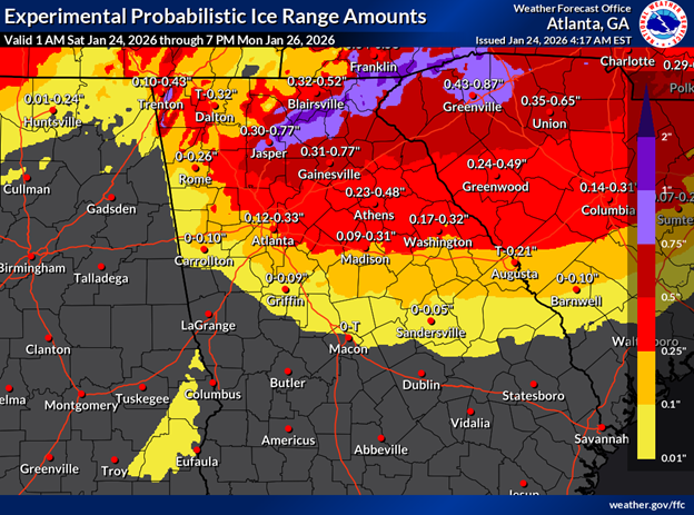
ICE ACCUMULATION PROBABILITIES
The NWS provided these graphics to us this morning that show their highest risk areas as currently forecasted. The NWS talked a lot about the wedge (the area of cold air damming on the eastern side of the Appalachians) that will HEAVILY influence where we get rain versus where we get frozen rain (ice). Campus and metro Atlanta are on the edge of where we think the cold air will reach. In the graphic below we are on the border between a tenth of an inch and a quarter on an inch.
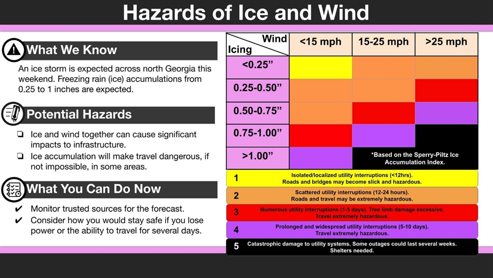
WIND & OVERALL RISK
When the NWS assesses risk with ice storms, they also factor in wind gusts, which can exacerbate tree damage and ultimately power outages. For this event, wind gusts will generally stay in the 20-30 mph range.
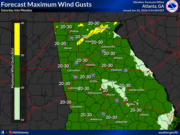
Although gusts in that range are not normally an issue for the region, when coupled with ice-laden trees and powerlines, failures are more likely to occur. In the graphic below you can see an overall risk when coupling wind gusts with ice accumulations. With such a tight gradient of ice accumulations the metro Atlanta area needs to continue to prepare for red (level 3) and purple (level 4) impacts, but could have luck on our side and be in the orange (level 2). As always, campus will likely avoid most impacts to power with our underground utilities.
POTENTIAL IMPACTS TO REGION
Given the potential ice accumulation across the region, especially the northwest metro counties, and likelihood of gusts >25 mph, impacts at Level 3 are possible. To the northeast, impacts at level 4 and even level 5 are possible. This means that for many in the region, lengthy (1-5 days) and widespread power outages are likely with treacherous roads, and in some cases, impassable roads due to downed trees and powerlines.
POTENTIAL IMPACTS TO CAMPUS
Having said that, impacts on campus should be better. Our power distribution is largely underground and will mitigate our vulnerability to power failure. We remain confident that the campus will maintain power for this event. Still, areas immediately around campus may have less success and see power outages. Impacts on campus will largely be felt with regard to roadways, sidewalks and vegetative damage. Ice accumulations on roadways and sidewalks during these events is difficult to mitigate and remove. We will have crews operating throughout the event to maintain clear paths of travel, but be mindful that at times, campus travel may be difficult.
POST EVENT TEMPERATURES
We’re still anticipating very low surface temperatures on Monday and continuing through at least Tuesday morning. Persistently cold temperatures are possible throughout the week, with few hours above freezing in the forecast between Monday and next weekend.
CAMPUS PREPARATION
With Modified Operations having been called, our campus partners have shifted operations. For the latest on campus operations visit https://www.gatech.edu/emergency/weather/updates. Decisions regarding operations on Monday will be made on Sunday and communicated out broadly.
NEXT STEPS
- Emergency Operations meetings will continue today at 3 PM.
- The Georgia Tech Police Department Office of Emergency Management will continue to monitor the situation and provide updates as necessary.
- Follow the GT Office of Emergency Management on twitter @gtpdalerts.
- For the latest forecast information, please visit the National Weather Service.