WHAT’S CHANGED
An Ice Storm Warning was issued for much of northeast Georgia, including both Forsyth and Hall Counties. The Winter Storm Watch remains in effect for the rest of North Georgia and parts of Middle Georgia. Expect additional counties to be added to the Ice Storm Warning area later today. For now, though, they are most confident in destructive ice accumulations in the warned area. As far as the models go, they are becoming more aligned with a strong wedge across the piedmont – something that NWS Peachtree City has been concerned about for the past few days, despite model variance.
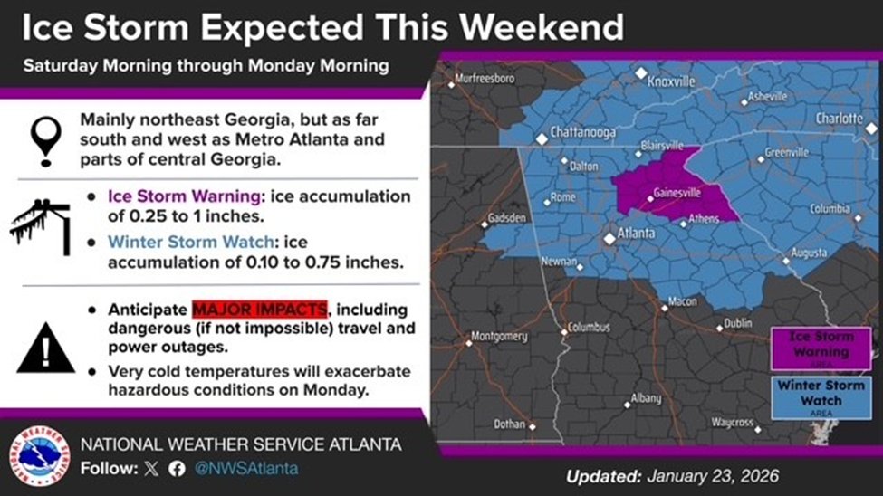
Figure 1: Winter Storm Watch & Ice Storm Warning Areas
TIMING
Generally, we should start to see freezing precipitation impact the region by late afternoon on Saturday. However, this system is a rain-maker, with liquid equivalent totals in excess of 2” across the entire region. In over-running setups like this, precipitation onset may start before models indicate and then persist through the event. Thus, the onset is likely late afternoon Saturday, but earlier onset is certainly possible. We continue to provide conservative guidance to operational partners to have travel to/from campus completed by midday on Saturday. The system should exit our area by late Sunday, although this time is pushing forward a bit from earlier models.
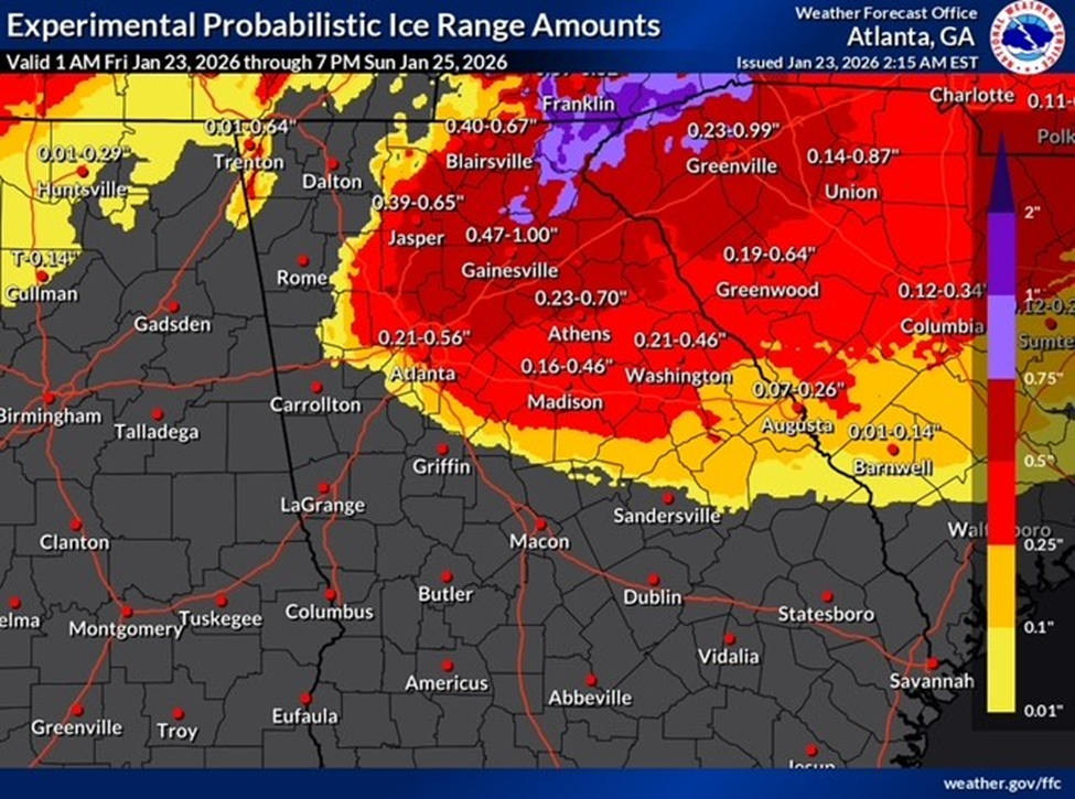
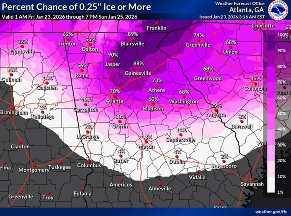
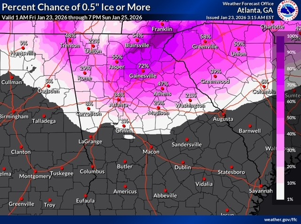
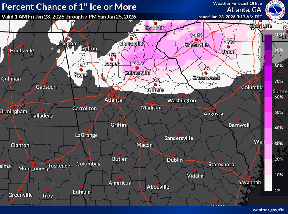
ICE ACCUMULATION PROBABILITIES
The NWS provided these graphics to us this morning that show their highest risk areas as currently forecasted. Note that with all other things equal, probabilities will increase as we approach the impact period. This area is primarily dependent on the strength and extent of the wedge. The precipitation will be there across the entirety of the region.
WIND & OVERALL RISK
When the NWS assesses risk with ice storms, they also factor in wind gusts, which can exacerbate tree damage and ultimately power outages. For this event, wind gusts will generally stay in the 20-30 mph range.
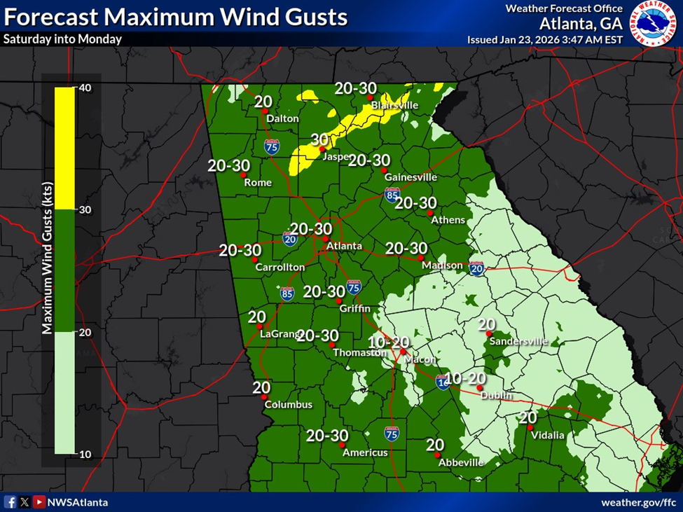
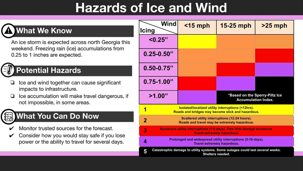
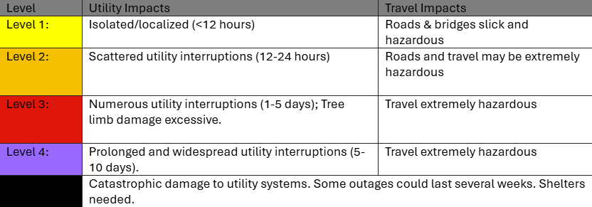
Although gusts in that range are not normally an issue for the region, when coupled with ice-laden trees and powerlines, failures are more likely to occur. In the graphic below you can see an overall risk when coupling wind gusts with ice accumulations. Many parts of the region will find themselves in the red (level 3) and purple (level 4) ranges.
POTENTIAL IMPACTS TO REGION
Given the potential ice accumulation across the region, especially the northwest metro counties, and likelihood of gusts >25 mph, impacts at Level 3 are likely. Impacts at Level 4 & Level 5, especially to the northwest are possible! This means that for many in the region, lengthy (1-5 days) and widespread power outages are likely with treacherous roads, and in some cases, impassable roads due to downed trees and powerlines.
POTENTIAL IMPACTS TO CAMPUS
Having said that, impacts on campus should be better. Our power distribution is largely underground and will mitigate our vulnerability to power failure. We remain confident that the campus will maintain power for this event. Still, areas immediately around campus may have less success and see lengthy outages. Impacts on campus will largely be felt with regard to roadways, sidewalks and vegetative damage. Ice accumulations on roadways and sidewalks during these events is difficult to mitigate and remove. We will have crews operating throughout the event to maintain clear paths of travel, but be mindful that at times, campus travel may be difficult.
POST EVENT TEMPERATURES
We’re still anticipating very low surface temperatures on Monday and continuing through at least Tuesday morning. Persistently cold temperatures are possible throughout the week, with few hours above freezing in the forecast between Monday and next weekend.
CAMPUS PREPARATION
All of our operational partners have been planning over the past few days to maintain essential services on campus. Given the forecast and potential difficulty of recall, most units are planning to stage essential staff on/near campus by Saturday midday. Final decisions on weekend services will be determined today and communicated out broadly.
NEXT STEPS
- Emergency Operations meetings will continue today at 10AM.
- The Georgia Tech Police Department Office of Emergency Management will continue to monitor the situation and provide updates as necessary.
- Follow the GT Office of Emergency Management on twitter @gtpdalerts.
- For the latest forecast information, please visit the National Weather Service.