OVERVIEW
A significant winter storm is posed to impact our region beginning on Saturday and ending late Sunday, with heavy ice accumulations expected. A Winter Storm Watch has been issued for much of north Georgia including parts of north Metro Atlanta, with extension of that Watch into our area likely.
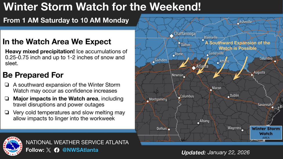
Figure 1: Guidance from NWS
Lengthy and widespread power outages are possible depending on the intensity and extent of freezing rain coverage over the region. Models continue to signal that excessive ice accumulation (>1”) are very possible across much of the region. Typically, we see tree and powerline failures begin around ¼” of ice. Thus, forecasts of ice accumulations exceeding 1 inch are concerning.
COLD AIR DAMMING & MODEL DIVERGENCE
Where the ice sets up will largely depend on the cold air damming (CAD, often referred to as the “wedge”) that is forecasted to be set up along the eastern Appalachians and throughout the piedmont region. Please note that models often fail to forecast the wedge well in this area. As such, we do see some model divergence between the ECMWF and GFS largely due to the ECMWF underestimating the staying power of a strong wedge. The NWS has noted that historically, models have not handled how the wedge can be reinforced through evaporative cooling. In this setup, they are noting very low surface dewpoint temperatures along the piedmont in the classic wedge area. They are concerned that large scale evaporative cooling may cause the wedge to hold firm and possibly expand farther southwestward. In addition to the evaporative cooling possibility, a weak surface low off the Carolinas may reinforce the northeast winds along the piedmont, further reinforcing surface cold air in the region.
The wedge is important because areas outside of the wedge will largely be exempt from any ice accumulation. Temperature differences between areas within the wedge and outside of the wedge may exceed 30°F during the event! Thus, there will be a tight gradient between significant ice accumulation and no accumulation.
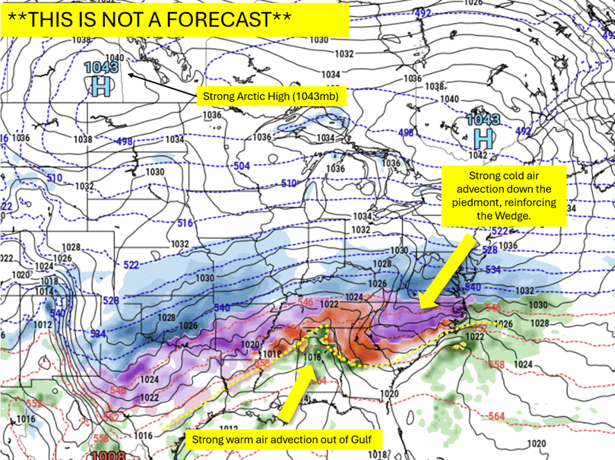
Figure 2: Factors at play
ICE ACCUMULATION
We expect very little snow from this event, possible only when the system kicks through late Sunday. The focus, instead, will be on ice accumulations. Ice accumulations, again, will be a controlled by the extent and strength of the wedge. The following graphics show different ice accumulation solutions from the ECMWF and GFS.
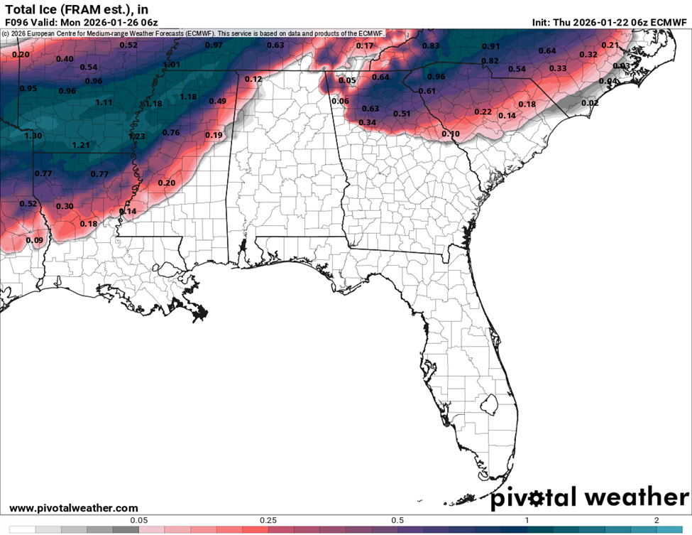
Figure 3: Ice Accumulation Total through Sunday (ECMWF 06z)
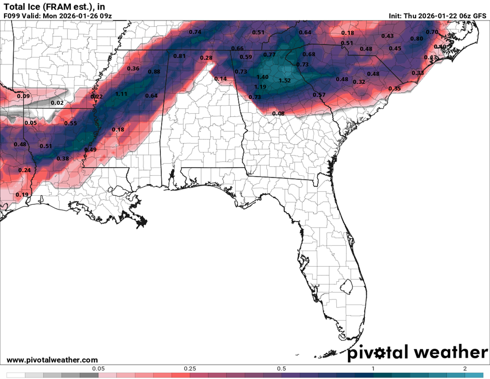
Figure 4: Ice Accumulation Total through Sunday (GFS 06z)
POST EVENT TEMPERATURES
Temperatures may rise slightly as the system kicks through late Sunday, but quickly fall below freezing on Monday with a deep freeze expected Monday night through Tuesday morning. Some models suggest temperatures dropping into the single digits Tuesday morning, but all models show a deep freeze over that period. This may cause further aggravation to areas hit hard by ice.
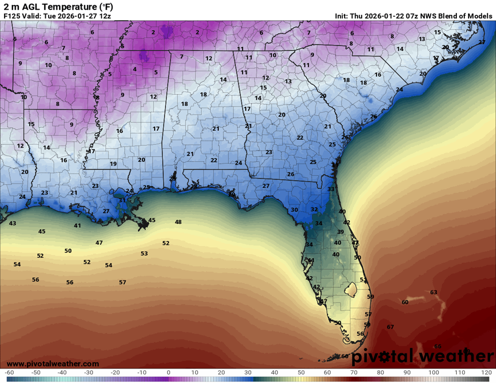
Figure 5: Surface Temperatures on Tuesday at 7 AM (NWS Blend 07z)
POTENTIAL IMPACTS
- Lengthy (multiple days – over a week) and widespread power outages across the region
- Downed trees on houses, overhead utilities and blocking roadways
- Travel disruptions due to ice accumulation
NEXT STEPS
- Emergency Operations meetings will begin today at 4PM.
- The Georgia Tech Police Department Office of Emergency Management will continue to monitor the situation and provide updates as necessary.
- Follow the GT Office of Emergency Management on twitter @gtpdalerts.
- For the latest forecast information, please visit the National Weather Service