OVERVIEW
A significant winter storm is possible this weekend, with potentially lengthy impacts across the region. Long-term power outages and interruptions to both air and ground transportation are possible across much of the South. Although we have seen some shifts in models over the past 24 hours, preparations should continue. We should start to see more short-term models come into play by midday tomorrow, hopefully offering more clarity and confidence on the forecast. For now, confidence remains low on p-type and p-type totals. The biggest factors in this forecast are 1) the extent of the warm nose moving northeastward from the Gulf and 2) the extent of cold air damming, often referred to as the wedge (see image, below).
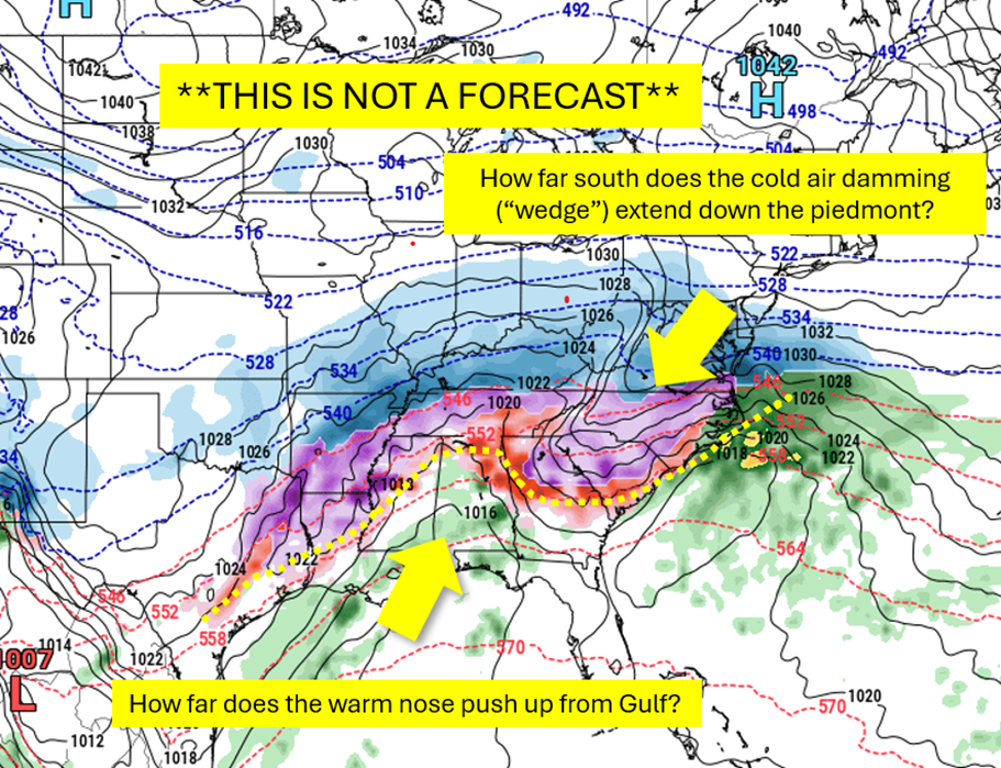
Warm, moist air moving out of the Gulf will join with an eastward-flowing transport of Pacific moisture to overrun an arctic air mass moving in from the north. This arctic air will spill down the eastern side of the Appalachians and dam up at the surface. Atlanta is typically near the southwestern extent of such a “wedge.” This means that we often have tricky forecasts for ice. With strong cold air damming in this scenario, we will have the right ingredients for significant ice. With a weaker wedge, icing may be limited.
The models are showing more disagreement on timing than previously. The ECMWF is suggesting a later arrival and shorter overall duration (Late Saturday – Sunday PM) and the GFS is showing an earlier arrival and longer overall duration (Early Saturday – Sunday PM). Both suggest an exit by late Sunday.
Behind this storm there is the possibility of extremely low temperatures, depending on snow and ice accumulations. Should we have significant accumulations followed by persistent cold temperatures, aggravating recovery and cleanup.
POTENTIAL IMPACTS
- Lengthy (multiple days – over a week) and widespread power outages across the region
- Downed trees on houses, overhead utilities and blocking roadways
- Travel disruptions due to accumulations of snow and ice
NEXT STEPS
- Emergency Operations meetings will begin today at 4PM.
- The Georgia Tech Police Department Office of Emergency Management will continue to monitor the situation and provide updates as necessary.
- Follow the GT Office of Emergency Management on twitter @gtpdalerts.
- For the latest forecast information, please visit the National Weather Service