OVERVIEW
The Office of Emergency Management (OEM) is monitoring the forecast for the possibility of winter weather Saturday night into Sunday morning. While there is still some uncertainty in some aspects of the forecast, models agree that low temperatures into Sunday morning will be in the upper 20s, allowing any moisture to make it to the surface as snow. Models also remain consistent on precipitation timing, beginning late Saturday night into Sunday morning. However, consistency with moisture amount and location remains split, keeping forecast confidence low. Snow remains the primary precipitation type, if it affects the area. Ice and sleet chances are low to none.
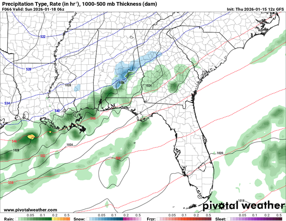
Figure 1: GFS from Thurs 1/15 (12Z run). Image showcases potential snow (light blue shading) in Fulton County on Sunday 1 AM local time
While campus may check off some necessities for winter weather impacts—being below-freezing—where the moisture passes through will determine if it remains cold but clear on Sunday or if we get snow. Models have divided into more northern and southern trends, each bringing great differences in impact to the area.
Preceding any potential snow early Sunday, a cold front will move through the area Friday evening into Saturday morning. This may impact any preemptive snow weather preparations. Depending on how quickly the weather clears out, Saturday afternoon could remain cool and cloudy or we could get sunshine and warm to the mid 40s or low 50s.
Both northern and southern model trends have one thing in common – a tight snow gradient. The difference in getting several inches of snow and just a dusting could be a one county to the next depending on where the moisture sets up.
With such a large degree in uncertainty among the models, OEM will continue to monitor the situation through the coming days. As we are headed into a holiday weekend, please monitor your emails for updates and ensure your team is aware of the forecast.
With that said for Atlanta and the Georgia Tech campus, this system may create quite a bit of travel havoc across the eastern United States, with some areas along the eastern seaboard receiving significant winter impacts. Be mindful of this if you or staff are traveling over the weekend.
PRIMARY HAZARDS
- Cold Temperatures
- Possible Snow
- Holiday Travel
- If snow falls, any melt may refreeze into ice Sun overnight into Mon.
NEXT STEPS
- The Georgia Tech Police Department Office of Emergency Management will continue to monitor the situation and provide updates as necessary.
- Follow the GT Office of Emergency Management on twitter @gtpdalerts.
- For the latest forecast information, please visit the National Weather Service.